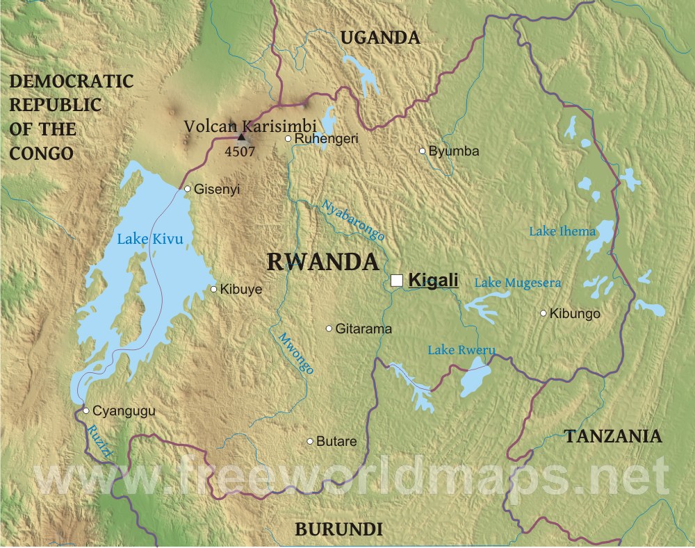
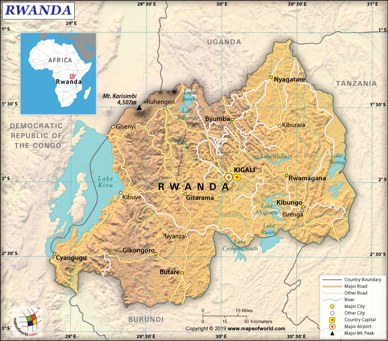
Explore the stunning physical map of Rwanda, a nation known as the 'Land of a Thousand Hills.' This guide delves into its diverse topography, from the mountainous west along the Albertine Rift to the central plateau and eastern savannas. Understanding Rwanda's physical geography is crucial for anyone planning to visit its national parks like Volcanoes or Nyungwe, or exploring Lake Kivu. Discover how its elevation influences climate, biodiversity, and agricultural practices across different regions. This informational resource provides essential insights for students, travelers, and researchers seeking a comprehensive overview of Rwanda's natural landscape, offering a navigational understanding of its unique environmental attributes and geographical wonders for a richer experience. Locate prominent rivers, lakes, and volcanic peaks with ease.
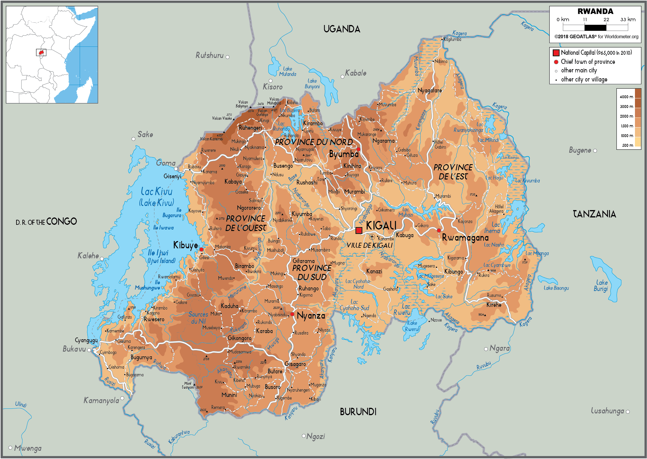
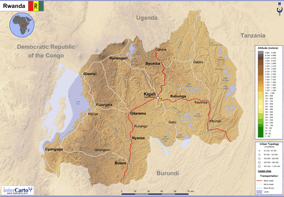
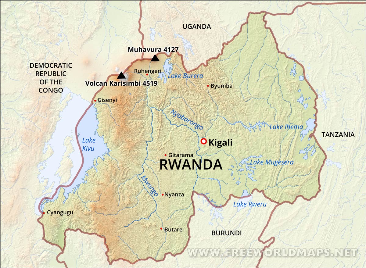
- What are the primary topographical features of Rwanda visible on a physical map? - Rwanda's physical map primarily displays high mountains in the west, including the Virunga chain, a central plateau with rolling hills, and lower-lying savannas and wetlands in the east. Lake Kivu dominates the western border, alongside numerous smaller lakes and rivers.
- Where can I locate the highest mountain peaks in Rwanda using a map? - The highest mountain peaks in Rwanda are located in the northwestern part of the country, specifically within the Virunga Mountains. Mount Karisimbi, at 4,507 meters, is the tallest peak and can be clearly identified on detailed physical maps of the region.
- How does Lake Kivu appear on the physical map of Rwanda and what is its significance? - Lake Kivu appears as a large, irregularly shaped body of water along Rwanda's western border with the Democratic Republic of Congo. It's a key feature, known for its deep waters, numerous islands, and economic importance for transport and fishing.
- What major rivers and water bodies are shown on a physical map of Eastern Rwanda? - On a physical map of Eastern Rwanda, the most significant water body is the Kagera River, which forms much of its eastern border. Several lakes, including Lake Ihema, Lake Mugesera, and Lake Rweru, are also prominent features in this flatter, savanna-dominated region.
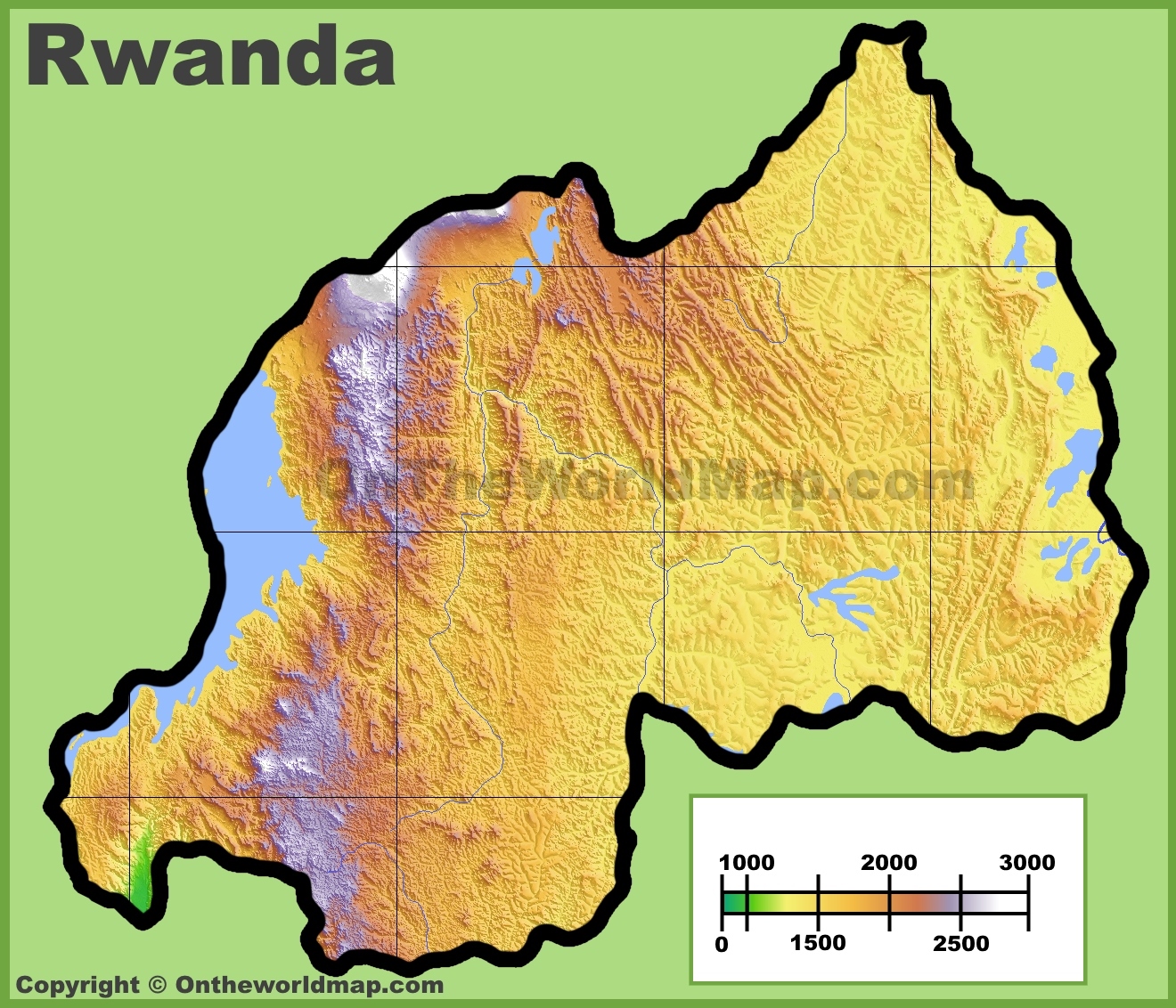
- Can a physical map of Rwanda illustrate its 'Land of a Thousand Hills' nickname? - Absolutely. A physical map of Rwanda vividly illustrates its 'Land of a Thousand Hills' nickname through contour lines and elevation shading. The map clearly shows the country's extensive undulating terrain, numerous hills, and mountainous ranges across nearly its entire landmass.
- Which national parks in Rwanda are directly linked to distinct physical geography? - Volcanoes National Park is synonymous with the Virunga Mountains and volcanic terrain. Nyungwe Forest National Park is situated in the southwestern highlands, known for its ancient rainforest. Akagera National Park encompasses eastern savannas, wetlands, and lakes, each reflecting unique physical geography.
- How does the physical map of Rwanda inform understanding of its climate zones? - The physical map of Rwanda shows higher elevations in the west leading to cooler, wetter climates suitable for cloud forests. The central plateau experiences moderate temperatures, while the lower, flatter eastern savannas are warmer and drier, demonstrating a direct correlation with topography.
- What are the main geographical regions of Rwanda?
- Rwanda is characterized by three main geographical regions: the mountainous western region (part of the Albertine Rift), the central plateau, and the eastern savannas.
- Which major lakes and rivers are featured on Rwanda's physical map?
- Prominent lakes include Lake Kivu, Lake Muhazi, Lake Rweru, and Lake Ihema. Major rivers include the Kagera River (forming part of the eastern border) and the Rusizi River.
- Where are the highest points located on a physical map of Rwanda?
- The highest points are found in the Virunga Mountains in northwestern Rwanda, with Mount Karisimbi being the highest peak at 4,507 meters.
- How does Rwanda's physical geography influence its climate?
- Rwanda's high elevation contributes to its temperate climate, despite being near the equator. The mountainous west is cooler and wetter, while the eastern savannas are warmer and drier.
- What major national parks are linked to Rwanda's physical features?
- Volcanoes National Park is in the mountainous northwest, Nyungwe Forest National Park is in the southwestern highlands, and Akagera National Park is in the eastern savannas.
- Can I see evidence of volcanic activity on Rwanda's physical map?
- Yes, the Virunga Mountains in the northwest clearly show a chain of volcanoes, including several active ones, indicating significant past and present volcanic activity.
- What is the 'Land of a Thousand Hills' and how does it relate to Rwanda's physical map?
- 'Land of a Thousand Hills' is a descriptive nickname for Rwanda, accurately reflecting its highly undulating and mountainous terrain, clearly visible across most of its physical map.
Welcome to your quick guide on the physical map of Rwanda, the stunning 'Land of a Thousand Hills.' If you're looking to understand its unique geography, from its majestic mountains to its expansive lakes, you've come to the right place. This article cuts through the noise to give you the essential details about Rwanda’s diverse landscape, perfect for planning your next adventure or simply satisfying your curiosity about this beautiful East African nation.
Frequently Asked Questions
Where can I find the most prominent physical features on a local map of Rwanda?
The most prominent physical features are found in **Western Rwanda** along the Albertine Rift, including the **Virunga Mountains** and **Lake Kivu**. The **central plateau** and **eastern savannas** are also key.
How can I use Local MAP or Maps apps to explore Rwanda's physical geography?
Pull up your preferred mobile Maps app to explore Rwanda’s diverse terrain. Zoom in on areas like Volcanoes National Park to see mountain ranges or Lake Kivu for its extensive water body, verifying real-time access information for parks and major landmarks.
What are the best times to visit specific physical regions for optimal viewing?
The best times to visit mountainous regions like Volcanoes National Park are during the dry seasons, typically June to September and December to February, for clear views and easier trekking conditions.
Quick Local Guide Table or Scannable List
Here’s a snapshot of Rwanda’s key geographical features and their associated regions:
- Virunga Mountains - Northwestern Rwanda
- Lake Kivu - Western Rwanda (border with DRC)
- Nyungwe Forest - Southwestern Rwanda
- Akagera River - Eastern Rwanda (forms border with Tanzania)
- Central Plateau - Central Rwanda
- Mount Karisimbi - Northwestern Rwanda (part of Virungas)
- Rusizi River - Western Rwanda (drains Lake Kivu)
All maps focus on physical map of rwanda.
Rwanda's 'Land of a Thousand Hills' topography, Albertine Rift mountains, central plateau, eastern savannas, Lake Kivu, Volcanoes National Park, Nyungwe Forest, Kagera River, Akagera National Park, Virunga Mountains.


Physical Map Of Rwanda The Oxford Collection Ilovemaps . Physical Map Of Rwanda Ezilon Maps Rwanda Physical Map . Physical Map Of Rwanda Apiq6prga 77898 . Rapport Sur Le Rwanda Pdf Le Regard Du Pouvoir Rwandais Sur La France Rwanda Physical Map . Geography Rwanda 567494 Orig


Rwanda Physical Map Com Rwanda Physical Map . Rwanda Shape On White Physical Stock Of Shape Colored Elevation Map Lakes Rivers Rwanda Distance Scale Border Coordinates Isolated White Physical 301632233 . Rwanda Map Large Detailed Political And Map Of Rwanda With Roads Cities And Airports . Rwanda Physical Map Order And Download Rwanda Physical Map Rwanda Physical Map . Cartoons Vector Stock Images 8 Pictures Rwanda Hyghly Detailed Physical Map Highly Vector Format All Relief Forms Regions Big Cities 235358397



Country Profile Rwanda Screenshot 2024 07 16 At 12.29.59 . Rwandan Genocide Map Rwanda Physical Map . Maps Of Rwanda Collection Of Maps Of Rwanda Africa Mapsland Large Political And Map Of Rwanda With Roads Cities And Airports Preview . Rwanda Maps Facts World Atlas Rw 01 . Rwanda Physical Map Rwanda Map Physical


Rwanda Map Set Political Physical Road Network Printable Digital Il Hvap . Physical Map Of Rwanda Detailed Regions Map Of Rwanda . Search MERS Antique Books Antwerp Rwanda Map . Rwanda Map Location Rwanda Political Map . Pony Town Updated Map Of America Rwanda Map 2022 Update
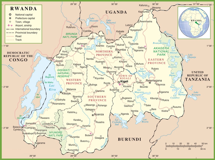


Rwanda Map Wikipedia Rwanda Political Map Max . Rwanda Religion Population Language Capital Britannica Rwanda Map Features Locator . Rwanda Map Rwanda Travel Maps Maps To Help You Plan Your Rwanda Rwanda Road And National Park Vector Map M1YPYJ . Rwanda Map Location Rwanda Map GKRN03 . List Of Rivers In Rwanda At Rachel Stewart Blog Rwanda Admin Map 2006


Rwanda Map Vector New 2024 Colorful Layered Political Map Rwanda Map Vector New 2024 Colorful Layered Political Map Of Rwanda With . India Map Picture Gifts Delight Laminated 24x28 Poster Political Map Physical And Political Map Of Rwanda Adobe Illustrator Ai 3507x2480 2NEC315 . The Geography Of Rwanda My Virtual World Trip 7 Geographic Map Of Rwanda Source Minaffet 2015 . Rwanda On Africa Map Rwanda Map FULVD Rwanda Political Map . Rwanda Location Description Rwanda Political Map


.gif)
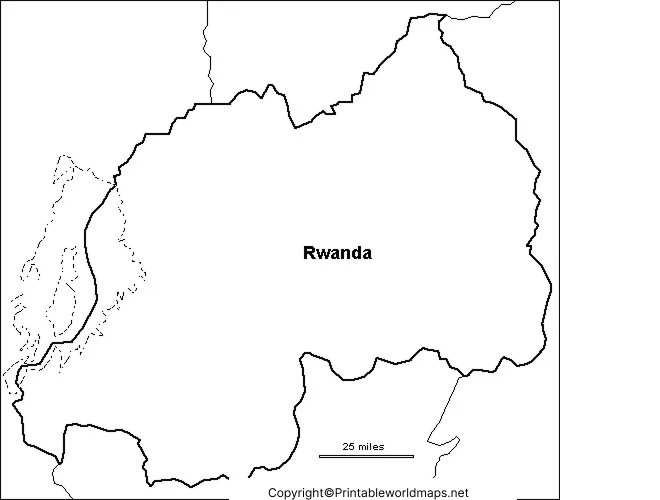
Rwanda Maps Facts World Atlas Rw 02 . Printable Blank Map Of Rwanda Outline For Educational Use Map Of Rwanda For Practice Worksheet . What Are The Key Facts Of Rwanda Rwanda Facts Answers Map Of Rwanda . What Is Rwanda S Population At Chuck Miranda Blog 05 Population Density . RWANDA MAPS OF RWANDA RWANDA (4)