Navigate the complexities of wildfire risk in 2026 with our comprehensive guide, designed for Gen Z and Millennials. Understanding your local wildfire threat is crucial for safety and preparedness. This resource dives into how to effectively use wildfire risk maps, including advanced digital tools and local government resources. Learn to interpret risk levels, identify evacuation zones, and access real-time updates directly from your mobile Maps applications. We provide actionable steps to enhance your awareness, leveraging the latest technology to safeguard your property and community. Stay informed about the most current data, understand critical safety protocols, and utilize mapping features to plan emergency routes. Our aim is to make complex wildfire information accessible and actionable, empowering you to make informed decisions quickly. Discover why integrating wildfire risk map data into your daily planning is essential for a resilient future in potentially vulnerable areas. Get ready to explore the best resources available for wildfire risk assessment and mitigation. This guide will help you understand and act on critical information. Accessing accurate maps is a top priority.
- Where can I locate the most current wildfire risk maps for my specific area in 2026? - The most current wildfire risk maps are found on official government sites like the USDA Forest Service Wildfire Risk to Communities tool, your state's forestry department, or county emergency management websites. These resources provide up-to-date, localized data essential for community preparedness and safety planning.
- How do popular mobile Maps applications assist with wildfire risk assessment and evacuation planning? - Mobile Maps applications integrate real-time data from local emergency services during incidents, displaying active fire perimeters, road closures, and designated evacuation routes. They help users visualize safe pathways and potential hazards, allowing for immediate navigation and informed decision-making during fast-evolving wildfire events and critical situations.
- What are the recommended intervals for reviewing updated wildfire risk information and personal preparedness strategies? - It is recommended to review updated wildfire risk information before peak fire season, during periods of high fire danger, and regularly throughout the year. Quarterly reviews of personal preparedness plans ensure all elements remain current, effective, and align with the latest local guidance and evolving conditions.
- What do the different color codes on a wildfire risk map signify for my property's safety? - Wildfire risk map color codes typically range from green (low risk) to red or purple (extreme risk), indicating varying levels of potential hazard. Users should always consult the specific map's legend for precise definitions, as interpretations can vary. Understanding these colors informs property safety measures.
- Can I find a wildfire risk map specifically tailored to my home or business address? - Yes, many state forestry departments, county planning offices, and some insurance companies offer tools to generate property-specific wildfire risk maps. These maps use detailed geographic and environmental data to assess the precise threat level to individual addresses, aiding in tailored mitigation efforts and insurance planning.
- How often are official wildfire risk maps updated with new data and forecasts? - Official wildfire risk maps receive updates with varying frequencies. General risk assessments based on climate and vegetation are often updated annually or seasonally. However, real-time incident maps for active fires are continuously updated, sometimes every few minutes, to provide the most current information during an emergency.
- What practical steps should I take if my property is located in a high-risk wildfire zone according to a local MAP? - If your property is in a high-risk wildfire zone, immediately focus on creating defensible space by clearing vegetation. Harden your home with fire-resistant materials, develop a clear evacuation plan for all occupants and pets, and assemble an emergency go-bag. Regularly check local emergency advisories and practice your plan.
- What is the current wildfire risk in my neighborhood for 2026? Official government mapping portals and local fire department websites provide the most up-to-date, hyper-local risk assessments, often refreshed daily or weekly based on weather and fuel conditions. Always verify information directly from authoritative sources for your specific location.
- Where can I find a detailed wildfire risk map for my property? Property-specific wildfire risk maps are available through state forestry services, specialized insurance risk assessment platforms, and some county planning departments. These tools use parcel data to show detailed hazard levels.
- How do I interpret the color codes on wildfire risk maps? Wildfire risk maps typically use a color gradient where green signifies low risk, yellow moderate, orange high, and red or purple extreme risk. Always refer to the map's legend for precise definitions, as classifications can vary by provider.
- Are wildfire risk maps available on mobile apps in 2026? Yes, several mobile apps in 2026 offer real-time wildfire risk data, incident alerts, and interactive maps. Examples include local emergency services apps, news apps with integrated fire trackers, and specialized wildfire monitoring applications.
- What proactive steps can I take based on my wildfire risk map? Based on your wildfire risk map, proactive steps include creating defensible space around your home, hardening your home with fire-resistant materials, developing an emergency evacuation plan, and assembling a go-bag. Understanding your specific risk empowers targeted mitigation.
- How frequently are wildfire risk maps updated in 2026? Wildfire risk maps are updated with varying frequencies in 2026. General risk assessments are often updated annually or seasonally, while real-time incident maps for active fires are updated continuously. Always check the map's timestamp for the latest data.
- Can I use Google Maps or Apple Maps to find wildfire evacuation routes? Yes, during an active emergency, Google Maps and Apple Maps often integrate official evacuation routes and road closures. Local emergency agencies may push these updates directly to map services, providing critical navigation assistance in real-time.
Understanding wildfire risk in 2026 is more critical than ever, especially for communities across the United States. Modern wildfire risk maps are sophisticated tools that provide vital information on potential fire hazards, helping individuals, families, and businesses prepare and protect themselves. These maps utilize advanced data analytics, satellite imagery, and localized environmental factors to offer a granular view of risk, moving beyond broad regional assessments to highly specific property-level insights. Knowing how to access and interpret these dynamic resources is fundamental for proactive safety measures.
Frequently Asked Questions
Where can I find the most accurate wildfire risk maps for my area in 2026?
The most accurate wildfire risk maps for your area in 2026 are typically found on official government websites. Key resources include the
USDA Forest Service Wildfire Risk to Communities tool and your state's forestry or fire department websites. For localized, immediate data, check your county emergency management services. Many insurance providers also offer proprietary risk assessments.
How do Local MAPs help me understand wildfire risks and identify evacuation routes?
Local MAPs are indispensable for understanding wildfire risks and planning evacuations. Pull up your preferred mobile Maps app to visualize designated evacuation routes, road closures, and shelter locations during an emergency. Many local emergency services now integrate real-time fire perimeter data directly into mapping platforms, offering critical updates. Regularly checking these maps, even during non-emergency times, helps familiarize you with safe pathways and potential hazards, ensuring quicker decision-making when it counts.
What are the best times to review updated wildfire risk information and preparedness tips?
The best times to review updated wildfire risk information are proactively before the peak fire season begins, typically in late spring or early summer, and whenever weather conditions indicate increased danger (e.g., high winds, drought). Additionally, regularly check for updates during active fire incidents or red flag warnings. Making it a monthly habit to review local alerts and preparedness tips ensures you are always ready for potential changes in risk levels. It is wise to review your plan quarterly and after any significant weather events.
Quick Local Guide List Wildfire Risk Resources
- Business Name: National Interagency Fire Center (NIFC)
- Neighborhood / Cross-streets: Boise Idaho (National HQ) - Online Resource for US
- Business Name: USDA Forest Service Wildfire Risk to Communities
- Neighborhood / Cross-streets: Nationwide Online Tool
- Business Name: CAL FIRE (California Department of Forestry and Fire Protection)
- Neighborhood / Cross-streets: California Specific - Online Resource
- Business Name: Local County Emergency Management Agencies
- Neighborhood / Cross-streets: Your specific County/City Websites
Access up-to-date wildfire risk maps 2026. Understand local threat levels. Utilize mobile Maps for real-time data. Identify evacuation routes efficiently. Learn preparedness strategies. Secure community safety.


U S Spring Break Travelers Warned Of Wildfire Alerts In Multiple Accuweather Spring 2026 Wildfire Risk Map Of The Us . Up To 8 Million US Acres To Burn Know 2026 Mississippi Wildfire Risk 89736153007 2026 . These Maps Show Exactly Where The West Might Burn This Summer Wildland Fire Potential Updated . U S Wildfires Have Already Claimed 1 4 Million Acres In 2026 And. How Do We Find And Protect Precious Wet Places In The West Working 2026 Fire Probability Map Great Basin 1080x1080
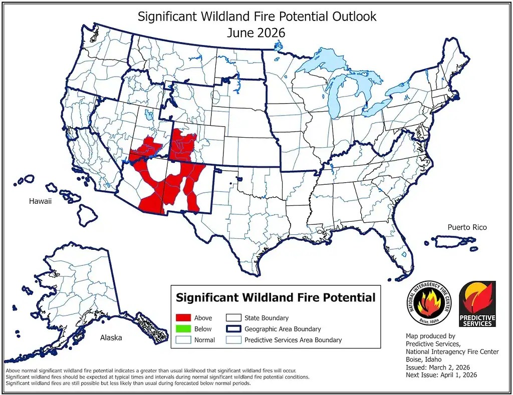


Terrifying New Maps Show The Entire West Is Facing An Extreme Wildfire Wildland Fire Potential Original. Significant Wildfire Potential Across Oklahoma South See 2026 Outlook. Summer Wildfire Risk Either Very High Or Unknowable News . Early Season Wildfire Risk Across The United States Operational Impacts Youth And Terrorism . Rain In Prince George Region Reduces Wildfire Risk Prince George Citizen Pgc 2026 06 05 Bc Fire Danger June 5 26 ;w=960

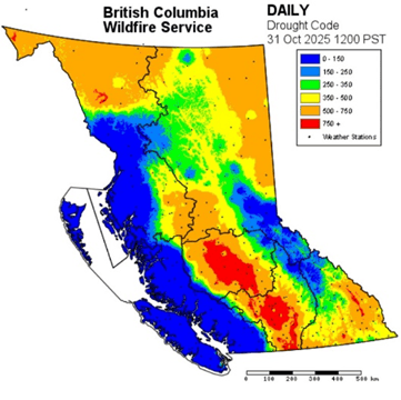


File Annual Area Burnt Per Wildfire North America 2026 Svg 960px Annual Area Burnt Per Wildfire%2C North America%2C 2026.svg . 2026 Wildfire Season Forecast PFLA Droughtcode . California Wildfire Risk Map How To Check Your Property 2026 Ember Pro Wildfire Risk Map California 1024x616 . Autumn 2026 Bushfire And Severe Weather National Response Untitled Design . What S The Probability Of A Rangeland Fire In The Great Basin In 2026 2026 Fire Probablity 2 1080x1080


File Annual Area Burnt By Wildfires World 2026 Svg Wikimedia Commons 960px Annual Area Burnt By World%2C 2026.svg . 2026 Study California Counties Most At Risk Of Wildfires California . Innovation For A Safer Future Looking Back At NOAA Research S 2025 Hourly Wildfire Potential Index 2048x1152 . AccuWeather S 2026 Wildfire Season Forecast Predicts 5 5 8 Million US Wildfire Forecast 2026 . File Annual Area Burnt Per Wildfire World 2026 Svg Wikimedia Commons 1280px Annual Area Burnt Per Wildfire%2C World%2C 2026.svg


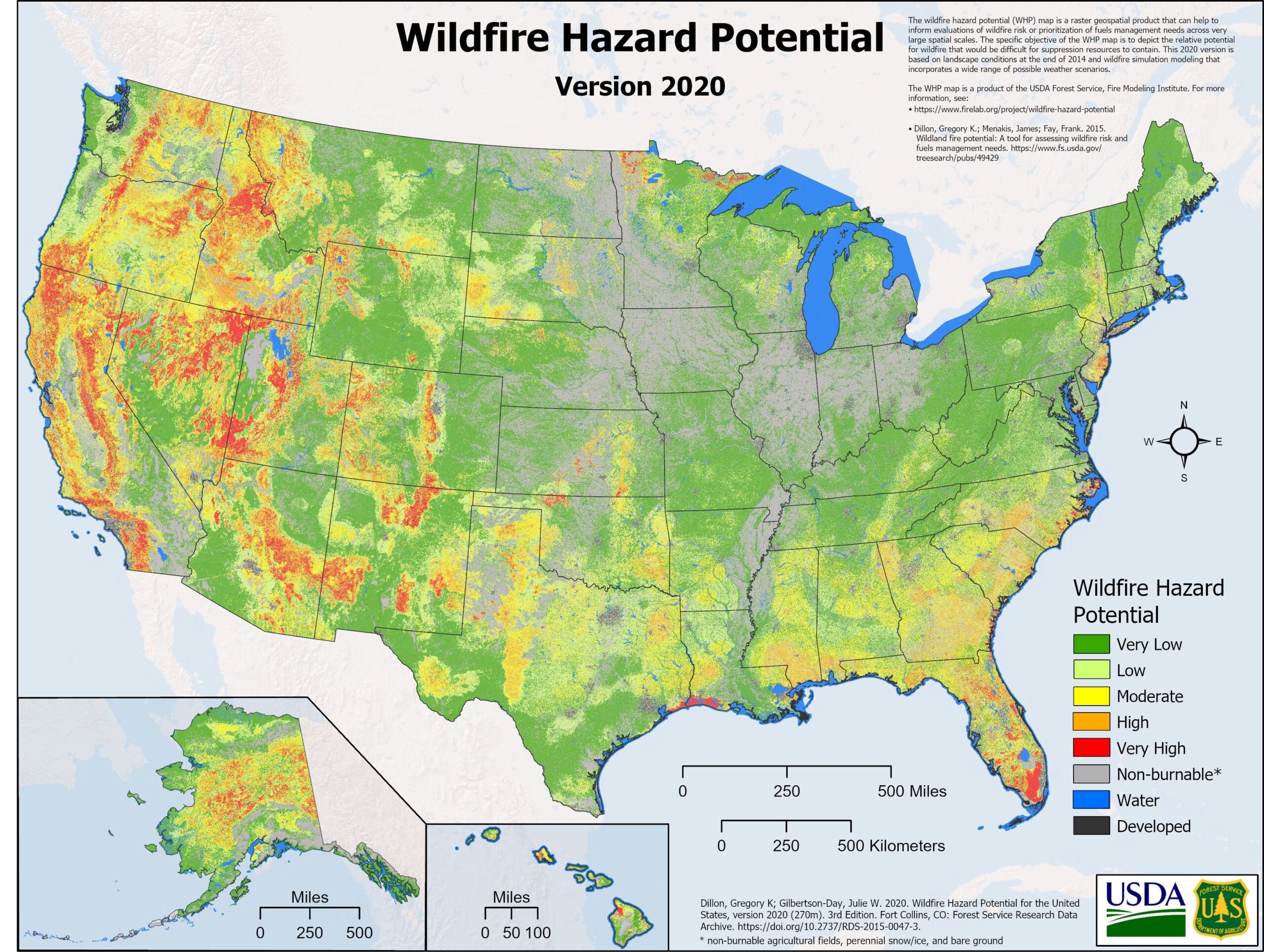

SCE S 2026 2028 Wildfire Mitigation Plan Esgvjcc Org East San G25 000 WMP 2026 2028 Fact Sheet 052125 1 . HazardHub Provides Critical Wildfire Risk Data And Maps Guidewire Pr 20240821 Wildfire Maps V2 800w . California S Highest Risk Wildfire Danger Zones In 2026 Californias Highest Risk Wildfire Danger Zones In 2026 A Guide 1.webp. AI Geospatial Wildfire Risk Prediction Towards Data Science Scaled . Map See Where Americans Are Most At Risk For Wildfires Washington Post Imrs.php
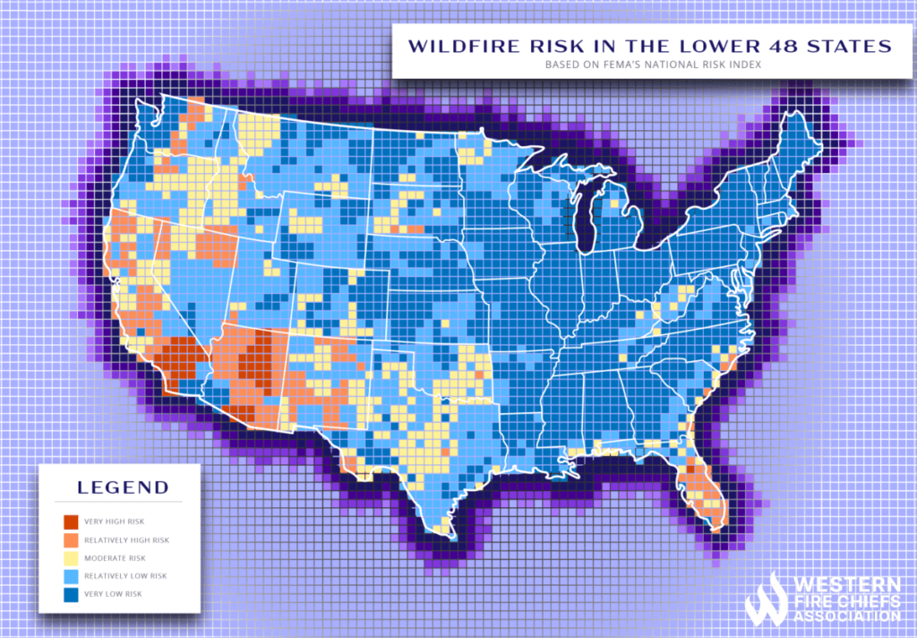


Fema National Risk Index Map Flood Hazard Map DTRVC USA Map Risk 1 01 1024x712 . Cal Fire Releases Updated Maps Showing Wildfire Risk Across Los Angeles 16077297 032425 Kabc Md Calfire Maps Vid . Europe Burns A View To The Summer Of 2026 Wildfire Today 2025 071025 Overall 1 . PGE S 2026 2028 Wildfire Mitigation Plan Updates Risk Maps Clearing . New Cal Fire Maps Show Increased Wildfire Risk In Redlands Fire Screen Shot 2025 03 30 At 11.04.09 PM


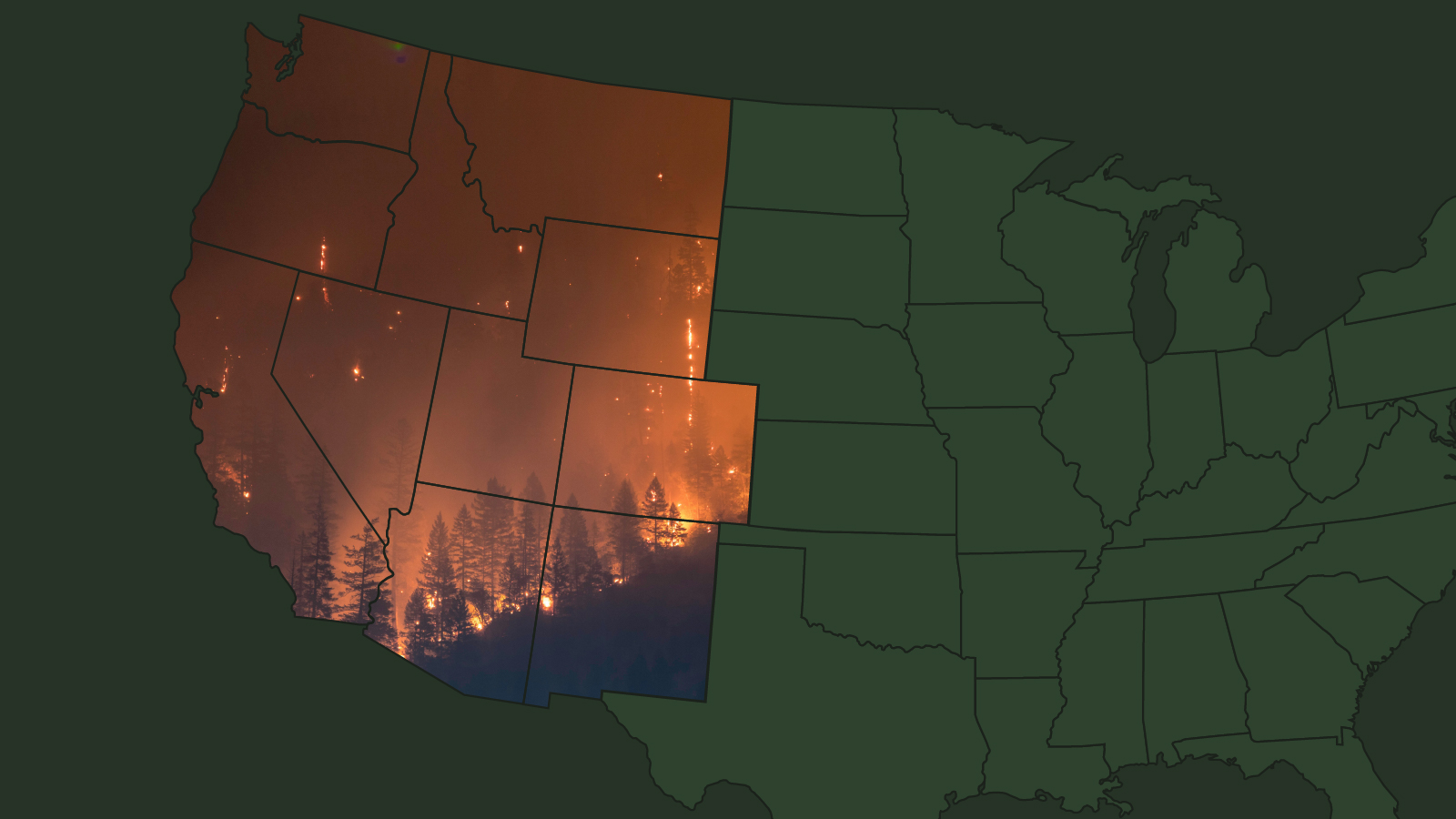
Wildfire Hazard Assessment Modeling At WAPA Explore Energy Wildfire Hazard Potential 2023 0 . California Fire Map Shows Areas In Greatest Danger As New Blazes Erupt Fire Risk Map . Roads Ignite Wildfire Risk Faster Than Policy Reacts NodeDrift Homes En Title Lg . See Where You Home Belongs In New California Fire Hazard Maps NBC Los Southern California To Get New Updated Fire Maps 1 . PERC Wildfire Risk Map PERC Cover Image